This article is brought to you by Datawrapper, a data visualization tool for creating charts, maps, and tables. Learn more.
A total eclipse in photos

Hi there — this is Shaylee from Datawrapper’s Customer Support and Success team. I wanted to document some snapshots of history this week.
This week, something happened with the moon. You may have heard about it or even seen it yourself, if you were one of the millions of lucky people in North America on April 8th, when a total solar eclipse crossed over Mexico, the United States, and Canada.
It was spectacular, or so I’ve heard. I live in Berlin, so I wasn’t able to witness the eclipse firsthand; my experience wasn’t through a pinhole camera, but through photographs others were able to capture. Fortunately for me, there are a lot of photos of this eclipse, even many taken from space!
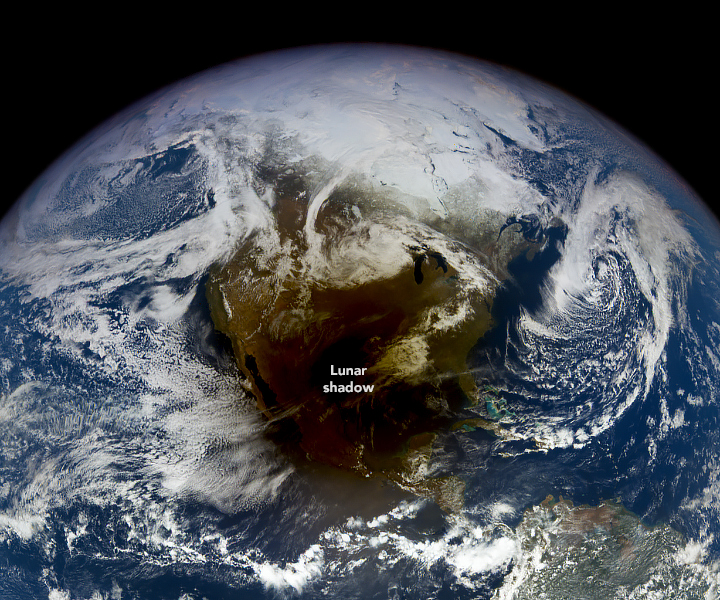
This eclipse was historic for a few reasons. Total eclipses are rare, since they require the sun, moon, and earth to be perfectly aligned, in that order, and at a very specific distance apart. When that happens, the moon takes up about the same amount of space in the sky as the sun does, and anyone standing directly in the moon’s shadow (the “path of totality”) will experience complete darkness as it passes over. Anything short of that will give you a partial eclipse, which is also what’s seen by people outside the path of totality.
A total eclipse can show special features like “Baily’s Beads” or the “Diamond Ring,” where the craters and curves of the moon let through bits of the sun’s photosphere, creating sparkling “beads” of light. Observing phenomena like these is important, since they can help scientists learn more about the exact shape of the sun and further our understanding of physics.

We’re also currently nearing a solar maximum, the high point of an 11-year cycle when the sun expels more material than usual into space, resulting in sunspots, solar flares, and coronal mass ejections.
Outside of the science, this eclipse was also special because its path was so large, ranging from 108 to 122 miles wide and passing over a more densely populated area than recent total eclipses have. NASA estimates that 31.6 million people were living in the path of totality, and 150 million were within 200 miles (about 322 kilometers, or a distance well worth traveling for a once-in-a-lifetime view!). The path looked like this:
With such a wide path to view from, there were eclipse gatherings galore across the entire continent.
- Some towns, like Houlton, Maine (the easternmost U.S. town in the path of totality), had been preparing for the eclipse for years, with tourism efforts centering around the slogan, "The end is here!"
- A Guinness world record was set in Niagara Falls when 309 people dressed up as the sun.
- Festivals and even mass weddings were held, like the "Total Eclipse of the Heart" festival in Russellville, Arkansas.
- Delta airlines offered a special eclipse flight from Dallas to Detroit, complete with “solar eclipse” Sun Chips, a Moon Pie, and eclipse glasses.
Beyond these headline-makers, there were also many more informal viewing parties. On April 8th, 2024, everyone paused for a moment to look up at the sky together: on mountainsides, beaches, and rooftops; from public parks and front yards; on lunch-break walks and mini road trips to empty fields. I know this not because I was there, but because there are photos of these moments, and the photos also hold a bit of eclipse magic, even if they’re not of the moon and sky.
I’ve collected some of my favorite photos, both of the sky and of the people who watched it, in the tooltips of this map:
How I positioned the photographs
When I was gathering this data, I didn’t have exact coordinates for every city where photos were taken, but I did know the city names — and that’s enough for Datawrapper's symbol map geocoder to find coordinates. I created a symbol map and pasted my city names in as data, generating latitude and longitudes to use in my locator map. I combined those coordinates with a pre-styled list of points in Google Sheets, using the method outlined here in our Academy. Being able to more or less automatically position and style the 35 points on this map made a huge difference in the process and the final product!
Thanks for reading! That’s it from me this week; tune in next week for a Weekly Chart from our developer Toni!


Comments